The "Xuannu Earth", a large geospatial embedded spatiotemporal intelligent base model independently developed by China, has been officially released.
On September 24, China's aerospace AI sector has achieved a major breakthrough. Beijing Xuannv Technology Co., Ltd. officially released its self-developed geospatially embedded spatio-temporal intelligent base large model — "Xuannv Earth", along with the supporting China-region embedded vector dataset, which is China's domestically developed "Chinese version of AlphaEarth Foundations (AEF)" product with higher accuracy.
The core technologies of "Xuannv Earth" such as the spatial grid and basic large model are independently developed by domestic teams. It innovatively adopts the technical system of "Earth embedding + multi-source data alignment", based on China's physical and geographical characteristics and industry application demands, and built on long-time-series, multi-modal remote sensing observation data including China's high-resolution and commercial satellite data. It realizes unified geoscience knowledge surface embedding representation that integrates meter-level data features under the 10-meter grid, building a domestically produced aerospace data AI base for key fields including natural resource supervision, ecological protection and restoration, disaster prevention and mitigation, and carbon sink accounting.
This official release covers two core achievements: the "Xuannv Earth" base large model and the embedded vector dataset. As the core "production tool", the base model realizes the extraction of general surface features from remote sensing images; the embedded vector dataset is a directly deployable "data product" generated by the model processing raw images. The two are oriented to model production and industry application scenarios respectively, jointly forming the underlying basic capabilities of Earth intelligence.
At present, the remote sensing application industry generally adopts the business logic of "application determines the model, the model determines the data, and the data determines the cost". Pulling the "leading head" of the application will lead to changes in the "trailing tail" of models and data, but there are problems such as high costs of data procurement, model R&D and commercial adaptation, and insufficient reusability. The launch of "Xuannv Earth" is expected to break this situation. Based on massive remote sensing images, the model deeply mines the laws of surface spectrum, texture, morphology, spatial correlation and time-series evolution, and converts them all at once into a standardized embedded vector set that can be reused infinitely. For multi-industry and multi-scenario applications in agriculture, natural resources, urban governance, ecological environment and other fields at the back end, users only need a very small amount of business labeling samples to train the "decoding head" of downstream tasks on site, and can quickly output thematic result layers that are more in line with the actual scenario of the problem, such as cultivated land, water bodies, buildings, roads, etc., which greatly reduces the threshold of downstream business development and commercial costs.
Both "Xuannv Earth" and Google's AEF Earth foundation model take generating surface embedding vectors by encoding multi-source and multi-temporal remote sensing data as the technical route, but there are obvious differences in positioning and capabilities. AEF focuses on the global scope and outputs annual-level embedding vectors; while "Xuannv Earth" focuses on China's region, providing higher-frequency quarterly-level embedding vectors, and monthly-level products will be launched successively. In addition, "Xuannv Earth" integrates more domestic satellite resources than AEF, including a large number of higher-precision meter-level satellite data, so it describes ground objects and geoscience processes more finely, and can adapt to richer application scenarios.
Earth intelligence is reshaping a brand-new way for mankind to understand the Earth and protect our homeland. The official release of "Xuannv Earth" is not the end, but a brand new starting point for the domestic Earth intelligence ecosystem to lead the world. In the future, the R&D team will continue to develop key core technologies, cooperate with universities, scientific research institutes and industrial partners to fully release the core value of aerospace data + AI, promote the large-scale application of Earth intelligence technology in actual business, and drive the leapfrog development of the commercial aerospace and geographic information industries with new thinking and new technologies.
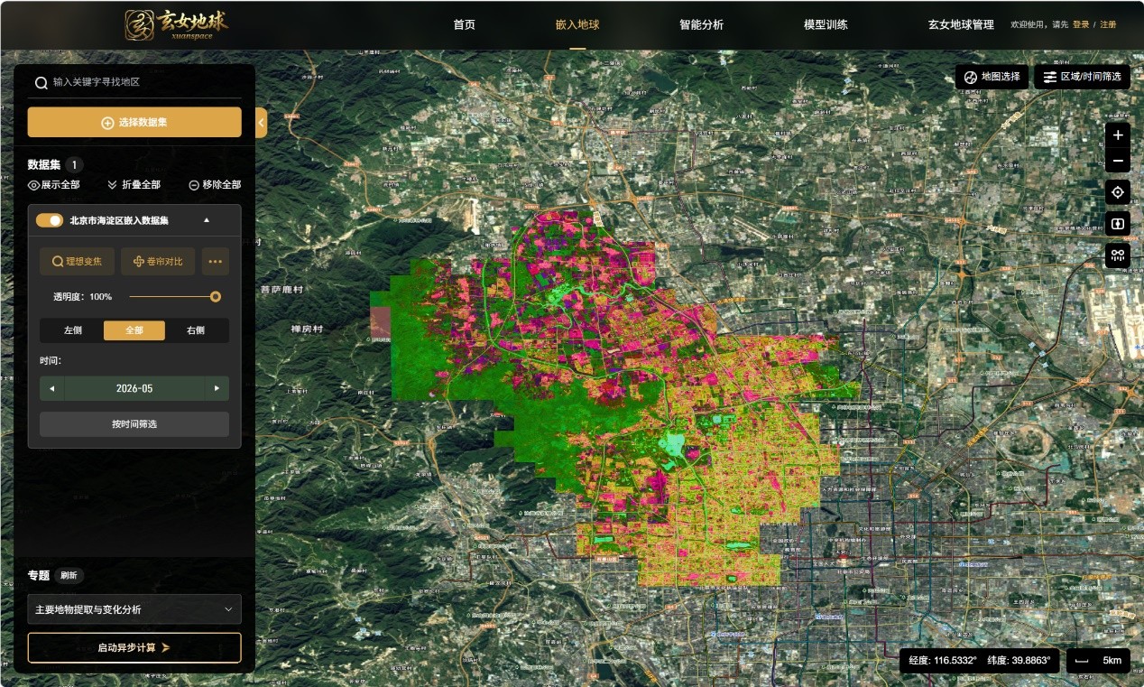
Xuannv Earth system operation interface
Expert Opinions:
Cao Bingxuan, Director of Digital Intelligent Ecology Innovation Center, China Urban Construction Research Institute Co., Ltd.
In the past, the common model in the remote sensing industry was that customers purchased various isolated data at high prices on demand in a decentralized manner, which not only resulted in high procurement costs, but also required a large amount of additional manpower for subsequent data cleaning, fusion and processing, leading to a long overall decision-making chain and extremely high comprehensive costs.
Xuannv Technology has reconstructed this logic: adopting a brand new model of "lightweight on-demand procurement + centralized large model processing". Customers no longer need to pay for scattered redundant data, nor do they need to undertake the subsequent complex data processing work, which can directly reduce the comprehensive decision-making cost for customers and improve the customer expansion capability of partners.
Yu Min, Professor and Senior Engineer, Head of Jiangxi Regional Center, China Urban Construction Research Institute
Based on geographic embedding technology, Xuannv Earth converts multi-source heterogeneous Earth observation (remote sensing) data into a unified and compact vector representation, which can effectively alleviate problems such as data overload, inconsistent standards and difficult cross-regional model migration in the ecological field. It can not only provide efficient and low-cost support for dynamic ecological monitoring and is expected to expand its functions to scenarios such as biodiversity protection and ecological risk early warning, but also serve as a physical quantity spatio-temporal base for natural resource asset accounting, dynamically updating the distribution, area and change patches of land, forest and grass, wetlands, water bodies and other assets, providing simple and efficient basic data support for the compilation of natural resource asset balance sheet, GEP physical quantity accounting and supervision and audit.