Leaping 8861 Meters: Understanding DJI's Technological Faith at the Top of the World
Many people first got to know DJI through aerial photography.
When a drone takes off, it frames mountains, rivers, cities and sea of clouds into the lens. For a long time, the public impression of DJI is that it allows ordinary people to stand at a higher perspective, look into the distance, and appreciate scenes that were previously only accessible to professional photographers and a small number of mountaineers.
This impression is not wrong, but far from comprehensive.
During the 2026 mountaineering season, DJI drones appeared on both the southern and northern slopes of Mount Everest. What they do is no longer just taking clearer photos of the mountain, but deeply participating in the daily operation of this top of the world: transporting supplies, clearing garbage, surveying glaciers, and carrying instruments into the sky. While other companies are still arguing fiercely over parameter upgrades and marketing slogans, DJI has quietly shifted its energy to places above 8000 meters above sea level, where there is no audience and no shortcut.
Two real-world challenges on the southern and northern slopes of Mount Everest
DJI completed two projects on the southern and northern slopes of Mount Everest this year. They seem very different on the surface, but share the same core: transferring the risks and limits that used to fall on humans to machines.
The southern slope operates a logistics system running under high pressure on the edge of life and death.
Every spring mountaineering season, mountaineers, guides, porters, route maintainers and logistics teams will enter the base camp and higher camps in a short period of time. Oxygen cylinders, food, fuel, ropes, ladders and camp supplies need to be transported to higher altitudes. Empty oxygen cylinders, packaging, discarded equipment and domestic waste also need to be carried down from high-altitude areas. This supply line cannot avoid a name — the Khumbu Glacier, which is densely covered with ice cracks and threatened by avalanches at any time, known as the "death trap". Over the past decades, Sherpa guides and porters have stepped out this road trip by trip with their own flesh and blood.
DJI only aims to solve one problem on the southern slope: can drones make one more trip to reduce the risk for people?
This mountaineering season, DJI cooperated with Nepali drone service company Airlift, and the FC100 transport drone shuttled between Everest Base Camp, Camp 1 and surrounding areas: transporting supplies uphill and collecting garbage downhill. The total transported supplies exceeded 10 tons throughout the season, of which nearly 3 tons of high-altitude garbage were removed. For the section that previously required manual crossing of the Khumbu Glacier, the one-way flight of the drone is reduced to about 8 minutes.
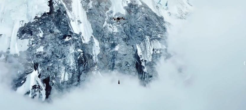
What it really changes is not just efficiency, but also the risk exposure time. One less trip carrying heavy loads, one less entry into the ice crack area, may mean a life for a mountain guide. Drones do not make Mount Everest easier, they just shift part of the risk from human shoulders to the drone's arms.
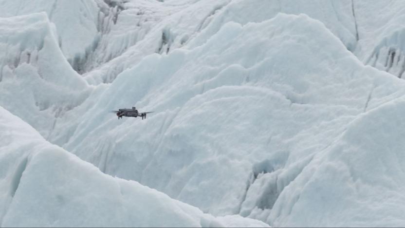
At the same time, the M4E surveying and mapping drone completed centimeter-level 3D modeling of the Khumbu Glacier, covering the base camp, the entire section of the Khumbu Icefall and areas above Camp 1. In the past, "glacier doctors" paved the way based on experience and on-site markers. Now, those ice cracks that are moving every day have for the first time a visualized, centimeter-accurate map.
On the northern slope, there is no large amount of back and forth of mountaineering logistics supplies, but there is a layer of air that humans have always found difficult to reach.
In the "Peak Mission" Everest scientific expedition, teams from Peking University, Chinese Academy of Sciences and other institutions want to find an issue that concerns all mankind: under the background of global warming, will pollutants in South Asia cross the Himalayas and pour into the Qinghai-Tibet Plateau? What paths do they follow for transmission? How do glacier winds affect all this? To answer this question, scientists urgently need real vertical distribution data of ozone and particulate matter above 8000 meters.
But this is almost an unsolvable problem: ground instruments can only measure a single point; satellite remote sensing does not have sufficient accuracy; sounding balloons drift with the wind and cannot be recovered; the downwash airflow of rotor drones will disturb the real wind field; the exhaust of oil-powered planes and helicopters will contaminate samples; traditional fixed-wing aircraft need runways — and there is no runway at all around the base camp at an altitude of 5200 meters.
This piece of the puzzle has long been missing.
DJI provided the answer. During the 12-day scientific expedition on the northern slope of Mount Everest, the DJI EV50 vertical takeoff and landing transport drone completed a total of 32 takeoffs and landings, with a continuous climbing height of 3730 meters, and the maximum flight altitude reached 8861 meters. It carried atmospheric data collection equipment to complete the observation mission, and still had 30% battery remaining when returning. With it, researchers for the first time fully "saw" the whole process of glacier wind from its initiation to impact — processes that could only be speculated through models in the past were truly recorded this time.
On the southern slope, people are pulled out of danger one more time; on the northern slope, atmospheric processes that were previously difficult to capture are turned into measurable data. At this point, the role of drones on Mount Everest has changed from a recorder to an execution tool for high-risk operations and scientific exploration.
Behind the word "reliability" lies 17 years of irreplicable accumulation
It is never a simple flight for drones to complete tasks on behalf of people on Mount Everest. It is an ultimate test of overall strength.
Low air pressure, extreme cold, strong wind, complex terrain and ultra-high altitude will simultaneously push the product performance of flight control, battery, power, communication and whole-machine reliability to their limits.
The confidence to withstand this test does not come overnight.
As early as 2009, Wang Tao, who was in the early stage of starting a business, under the guidance of Professor Li Zexiang, brought a small unmanned helicopter named "Everest" equipped with DJI XP3.1 automatic control system to the Everest area to complete flight tests. That year, DJI was little known, but it had already selected this harshest test field on the earth as its starting point.
The subsequent journey is piled up with a series of "down-to-earth hard work": 18 days of aerial photography test along the Sichuan-Tibet line in 2010; Phantom 2 Vision+ flew from 4500 meters to 5600 meters in Gongga in 2014; Mavic 3 completed the world's first drone shooting at the 8848.86-meter summit of Mount Everest in 2022. After 2024, its role was upgraded again, the FC30 transport drone completed the world's first high-altitude transport test at 6000 meters on Mount Everest for domestic civilian drones, which can stably carry 15 kilograms at 6000 meters; it entered seasonal operation on the southern slope in 2025; in 2026, the FC100 and M4E combination made its debut.
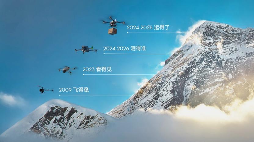
A clear evolution line has emerged from this: from "can it fly" to "can it shoot", then to "can it transport, can it measure, can it carry scientific instruments to complete tasks stably". The story of DJI and Mount Everest has gone through four eras: "flying stably → seeing the target → seeing clearly, being able to transport → flying higher".
The EV50 on the northern slope demonstrates this accumulation to the fullest. It takes off from the base camp at an altitude of about 5200 meters, and climbs all the way to 8861 meters, where the air density is only 39% of that at sea level, the temperature drops all the way to minus 20 degrees Celsius, and vertical wind shear may cause a sudden drop in relative airspeed at any time, bringing the risk of stall.
Facing this extreme environment, DJI's solution allowed the engineering team to add self-heating function to the battery, so that it can maintain output in low-temperature environments, and heat the pitot tube to prevent wet cold air from freezing and blocking the speed measurement channel. The flight control system keeps a close eye on the airspeed. Once the wind field changes and the airspeed drops, the thrust will be adjusted to pull the aircraft back to a stable state. Behind this capability, the team completed 875 sorties with a total of 254 flight hours during the 6-month preparation period.
This is exactly DJI's real product philosophy: let machines and engineering systems digest the most complex and dangerous parts, leaving predictable results on site. Guides no longer have to risk their lives, scientists no longer have to rely on luck. Scientific expedition is never a promise, but certainty brought by thousands of test flights. DJI has welded time, patience and paranoia for limits into the genes of its products.
From the top of the world back to daily life
What is really worth asking is where the capabilities verified on Mount Everest will eventually go.
For DJI, Mount Everest has always been like a ruler, used to measure the boundaries of products and technologies in extreme environments. What the EV50 verifies is not a "custom aircraft for Mount Everest", but a set of capabilities that can work stably in complex terrain. Such capabilities will eventually return to a wider range of real scenarios. What the EV50 initially aims to solve is also the more daily 100-kilometer-level transportation problem.
When the R&D team went to Danba, Western Sichuan for research, they found that counties and villages were separated by valleys, hillsides and winding mountain roads. Some villages are separated from the rural roads in the valley by a large height difference. It is very difficult for couriers to deliver goods, and in extreme cases, material transportation will stop for a whole week.
Another research scenario is between Ningshaan, Shaanxi and Xi'an. The parcel volume in Ningshaan County is small, and the cost of direct delivery to Xi'an is high. Traditional logistics usually needs to collect goods in Ankang first and then transfer to Xi'an. For express items, this detour will directly reduce the timeliness, and it is also difficult to find regular alternate landing points along the way.
Thus, the product logic of EV50 is clearly established: it needs to be able to take off and land in place without relying on runways, and fly as efficiently as a fixed-wing aircraft during the cruise phase to cover medium-distance transportation at the 100-kilometer level. Finally, the EV50 adopts the configuration of "8 sets of vertical takeoff and landing rotors + 3 sets of propulsion motors". During takeoff, 8 sets of vertical rotors lift the aircraft from the ground, and during cruise, 3 sets of propulsion motors are responsible for flying forward, the fixed wing provides lift, and the vertical rotors stop rotating and lock to minimize flight resistance.
The EV50 has a maximum load of 50 kilograms, a maximum cruise speed of 160 km/h, and a maximum effective range of 150 kilometers. Many express items are large in volume and light in weight, so the EV50 is designed with a 270-liter cargo hold. The safety design is also derived from actual operation scenarios: when some of the 8 vertical power modules fail, the aircraft can still land smoothly, and the propulsion system also considers the return capability after the failure of a single-side propulsion motor.
After all, what DJI has always been answering are the same set of most simple questions: can it fit? Can it fly far? Can it fly stably? Is it affordable? Can the task be completed safely even when some components fail?
In DJI's methodology, impressive parameters are only results, and usability in real scenarios is the starting point.
The 100-kilometer-level drone is designed to complement the existing logistics network, serving areas with high traditional transportation cost, high risk and poor timeliness. It is like an "air capillary" that fills the gaps in the end of the network. The value of drones is to deliver fire-fighting, medical, mountain rescue and emergency communication equipment to locations that ground transportation cannot reach in time. The flight control, power, surveying and mapping, transportation and scientific expedition capabilities that can operate smoothly on Mount Everest will have the opportunity to return to the foot of the mountain, and become robust, durable, affordable, and reusable inclusive tools in the real world.
In fact, this kind of protection does not need to wait for the future, it is happening every day. Take the current flood in Guangxi as an example, the Yunbiao, Liulan and other reservoirs in Hengzhou have overflowed and breached, a large number of villages and towns have become isolated islands in the water, with roads, networks and power cut off. Facing the disaster, DJI drones of various forms rushed to the front line: industrial drones undertook disaster reconnaissance and inspection, transmitting real-time images of flooded villages, breach risks and trapped positions back to the command center; agricultural and transport drones were "requisitioned" by a large number of operators as air lifelines, delivering mineral water, instant noodles, medicine and other urgently needed supplies to the people trapped by the flood trip by trip. At many isolated islands in the water, drones even pulled ropes in the air, directly lifting the trapped people out of the water and transferring them to safe areas. These machines, which were originally used for farmland plant protection and mountain transportation, have seamlessly become life-saving tools when disasters strike.
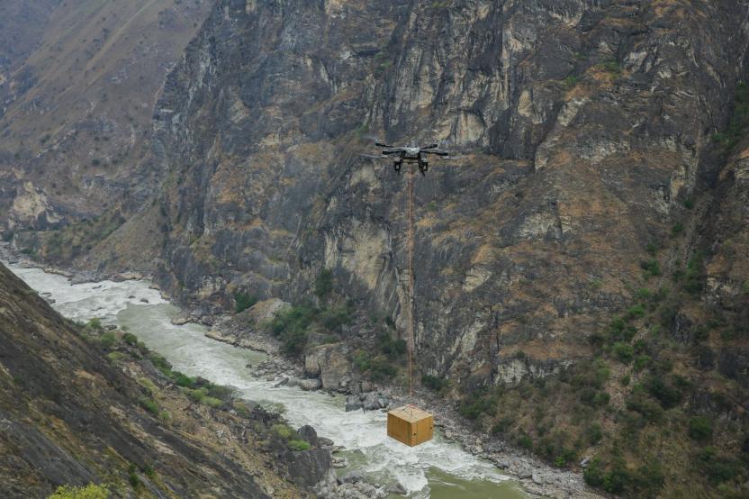
Such scenarios are no longer rare: in more and more flood, earthquake and wildfire sites, DJI drones have become one of the most common figures in the emergency response system — for reconnaissance, broadcasting, lighting, lifting and delivery. They may not be the protagonists under the spotlight, but they have put the phrase "protecting lives" into every race-against-time scene.
The reliability verified on Mount Everest is being transformed into protection for ordinary people across mountains and rivers again and again.
This is exactly the reason why DJI has been devoting itself to the research and practice related to Mount Everest for 17 years. In an era when everyone is looking for shortcuts, Mount Everest provides an examination room where no opportunism can work. It does not care about reputation or gimmicks, it only tests real capabilities.
The DJI familiar to the public is associated with aerial photography and landscapes, while the DJI on Mount Everest is associated with protecting lives, exploring the unknown and solving real pain points. Over the past 20 years, DJI started with flight control technology, and expanded to aerial photography, surveying and mapping, transportation and scientific expedition. The belief of geeks has finally turned into a warm power to protect lives and explore the unknown.
Looking down from the top of Mount Everest, what is truly vast is not only the mountains, but also the farmlands, canyon villages, island routes, glacier camps and high-altitude atmospheres waiting for technology to arrive.
DJI's climb has only just begun.