A hard-tech startup incubated by the University of Hong Kong secures tens of millions in financing. The world's first spatial memory module endows robots with spatial perception and memory capabilities | Exclusive from Yingke.
Author | Huang Nan
Editor | Yuan Silai
Yingke has learned that Shenzhen Liuxing Technology Co., Ltd. (hereinafter referred to as "Liuxing Technology") recently completed a Pre-A round of financing worth tens of millions of yuan. The investors in this round include Hony Capital, etc. The funds will be mainly used for the customized production of core components, large-scale product delivery, and market expansion. Previously, the company received seed-round investment from ZhenFund and angel-round investment from JunSheng Capital.
Founded in 2022, "Liuxing Technology" focuses on the development and application of intelligent 3D perception and reconstruction algorithms and products, aiming to endow embodied intelligent devices such as robots and drones with accurate spatial perception, intelligent memory, and active interaction capabilities. Its founding team was incubated at the MaRS Laboratory of the University of Hong Kong. The MaRS Laboratory focuses on drone design, navigation, and control, as well as lidar-based simultaneous localization and mapping (SLAM) technology. Professor Zhang Fu, the head of the MaRS LAB at the University of Hong Kong, serves as the company's technical strategic advisor. He was also an advisory scientist at DJI and one of the heads of Livox Lidar.
In recent years, with the in-depth integration of artificial intelligence and machine learning technologies, the accuracy and efficiency of 3D perception and reconstruction devices have been significantly improved. Some commercial software equipped with high-performance parallel computing capabilities can efficiently process massive amounts of data such as images and point clouds, and complete the 3D reconstruction of outdoor scenes and objects in a short time, demonstrating application value in multiple fields.
For example, in the field of cultural heritage protection, through high-precision digital replication of ancient buildings and cultural relics, not only is the permanent preservation of precious heritage achieved, but also new ways are provided for virtual display and public dissemination. This technology also shows great value in disaster relief scenarios. The collected 3D data can not only accurately restore the structure of the fire scene and trace the origin of the fire but also assist in the analysis of combustion patterns and the assessment of building safety, providing strong support for improving post-disaster response and protection capabilities.
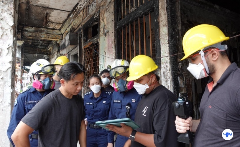
Application of the product in disaster relief (Source/Enterprise)
In the field of robotics, spatial perception and spatial memory capabilities are particularly crucial. When a robot is in a complex indoor or outdoor environment, it not only needs to perceive obstacles, narrow passages, and passable areas in real-time and accurately but also needs to have long-term memory and recognition capabilities of spatial positions to ensure stable autonomous navigation and path planning over a long period.
However, the current mainstream navigation and positioning solutions still have obvious pain points: traditional GPS signals cannot be stably received in indoor environments; indoor positioning technologies such as UWB and Bluetooth require the pre-installation of infrastructure, and the deployment process is complex and costly; the existing vision and lidar solutions have weak generalization ability and are difficult to handle complex and changeable environments, resulting in frequent perception errors, inaccurate positioning, and even work stagnation during the robot's navigation process.
Meanwhile, due to the extremely complicated hardware calibration of the existing navigation solutions, every time the environment or hardware device is changed, professional personnel need to spend a lot of time on complex parameter calibration. The development process is also time-consuming and labor-intensive. It not only requires processing massive amounts of image and point cloud data but also needs to repeatedly optimize the algorithm for different scenarios, greatly lengthening the project development cycle and increasing the cost of implementation.
To solve the above pain points, "Liuxing Technology" launched the world's first module product with both spatial perception and spatial memory functions - Liuxing Odin1, based on its self-developed all-solid-state, multi-sensor deep fusion architecture and MindSLAM™ high-performance algorithm.
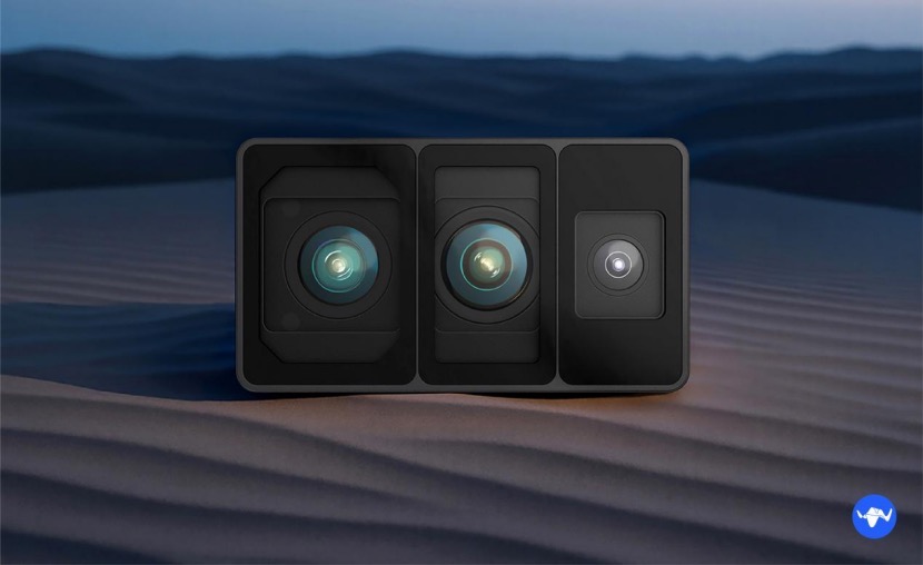
Rendering of Odin1 (Source/Enterprise)
Liuxing Odin1 innovatively integrates a SPAD dTOF depth module, a high-resolution color camera, and an IMU (Inertial Measurement Unit), enabling the native spatio-temporal synchronization of multi-sensor data and ensuring high consistency and accurate matching of data from different sensors during collection. Relying on the MindSLAM™ algorithm, Liuxing Odin1 can achieve centimeter-level positioning accuracy, with a maximum detection distance of 70 meters, a field of view of 120°×90°, and a point cloud output frequency of up to 700,000 points per second, greatly improving the fineness and integrity of spatial perception data.
Intelligent creatures usually rely on the hippocampus in the brain to achieve accurate memory and recognition of spatial positions. Among them, the Liuxing Odin1 module is equivalent to the "hippocampus" of a robot, providing it with stable and reliable spatial perception and spatial memory capabilities.
By accurately fusing data in the spatial and temporal dimensions, Liuxing Odin1 can actively build a high-precision spatial memory system and quickly construct an accurate 3D spatial model on this basis. Even in complex environments such as low light and featureless areas, intelligent vehicles such as robots and drones equipped with Liuxing Odin1 can accurately perceive the posture and position information of objects and actively remember the detailed layout of the space in real-time.
This ability significantly enhances the robot's intelligent cognition and interaction efficiency in complex environments, demonstrating outstanding advantages in fields such as autonomous navigation, path optimization, and efficient operation.
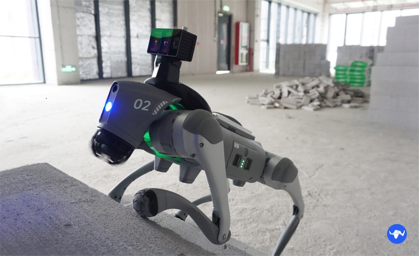
Application of a robotic dog equipped with Odin1 at a construction site (Source/Enterprise)
On the MindCloud platform developed by "Liuxing Technology", it can be seamlessly connected to the Liuxing Odin1 module, converting the collected real environment into a high-fidelity 3D simulation model with one click. It helps users easily collect, manage, and analyze 3D data to achieve the rapid construction of digital twin models and the efficient simulation training of robot algorithms, providing strong data support for robot intelligent decision-making and algorithm optimization.
Yingke has learned that currently, multiple real-time true-color 3D reconstruction products of "Liuxing Technology" have been widely used in scenarios such as building digitization, decoration measurement, restoration of fire rescue scenes, recording of traffic accident scenes, and industrial manufacturing.
For example, robots or drones equipped with Liuxing Odin1 can quickly enter fire scenes or emergency disaster areas, conduct real-time 3D spatial perception and modeling, and quickly provide accurate schematic diagrams of the site structure, providing important basis for rescue decision-making. During the building construction process, Liuxing Odin1 can also perceive and record the spatial changes at the construction site in real-time, accurately reflecting the construction progress and quality status, greatly improving the efficiency of project management and saving labor costs.
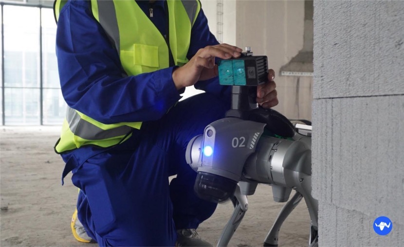
Workers installing Odin1 on a robotic dog (Source/Enterprise)
Currently, "Liuxing Technology" has carried out in-depth cooperation with multiple leading robot manufacturers. Through self-developed technologies, it has effectively reduced the overall cost of intelligent perception modules, launched cost-effective intelligent inspection and spatial perception solutions, and achieved the integrated fusion of navigation, scanning, and positioning functions. Liuxing Odin1 is planned to enter the mass production stage in July this year and will simultaneously layout the global market.