Flying 8,861 Meters High: At the Top of the World, Understanding DJI's Technological Faith
Many people got to know DJI through aerial photography.
A drone takes to the sky, framing mountains, rivers, cities, and sea of clouds in its lens. For a long time, DJI was perceived by the public as a brand that allowed ordinary people to stand at a higher vantage point, gaze into the distance, and appreciate scenes that were once only accessible to professional photographers and a handful of mountaineers.
This impression is not wrong, but it is far too narrow.
During the 2026 mountaineering season, DJI drones appeared simultaneously on both the southern and northern slopes of Mount Everest. What they were tasked with was no longer just capturing clearer footage of the mountain, but deeply integrating into the daily operations of this world's highest peak — transporting supplies, clearing waste, surveying glaciers, and sending scientific instruments aloft. While other companies were still fiercely competing over minor spec upgrades and flashy marketing slogans, DJI had quietly shifted its focus to altitudes above 8,000 meters, a place with no audience and no shortcuts.
On Both Slopes of Everest: Two Real-World Challenges
This year, DJI carried out two initiatives on the southern and northern slopes of Mount Everest. While they may seem vastly different on the surface, they share a single core purpose: transferring the risks and physical limits that once fell entirely on humans to machines.
The southern slope hosts a logistics system operating under extreme pressure, right on the edge of danger.
Every spring mountaineering season, mountaineers, guides, porters, route maintenance crews, and logistics teams flood into base camp and higher camps in a short period. Oxygen cylinders, food, fuel, ropes, ladders, and camp supplies need to be transported upward. Meanwhile, empty oxygen cylinders, packaging materials, discarded equipment, and domestic waste must be carried down from high-altitude zones. This supply route cannot avoid one critical landmark — the Khumbu Glacier. Dotted with hidden ice crevasses and prone to sudden avalanches, it is known as the "Death Trap." For decades, Sherpa guides and porters have blazed this path step by step, relying solely on their physical strength and courage.
On the southern slope, DJI set out to solve one single problem: can drones make more trips so that humans take fewer risks?
During this year's mountaineering season, DJI partnered with Nepali drone service provider Airlift, deploying the FC100 cargo drone to shuttle between Everest Base Camp, Camp 1, and surrounding areas — delivering supplies uphill and collecting waste downhill. Over the entire season, it transported more than 10 tons of materials in total, including nearly 3 tons of waste cleared from high altitudes. The segment that once required hours of manual labor crossing the Khumbu Glacier has been reduced to roughly an 8-minute one-way flight for the drone.
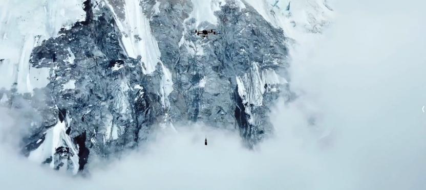
What it has truly transformed is not just efficiency, but the duration of human exposure to danger. One less heavy load to carry, one less trip into the ice crevasse zone — for a high-altitude guide, that could very well mean the difference between life and death. The drone has not made Mount Everest any easier to conquer; it has simply shifted a portion of that risk from human shoulders to the drone's airframes.
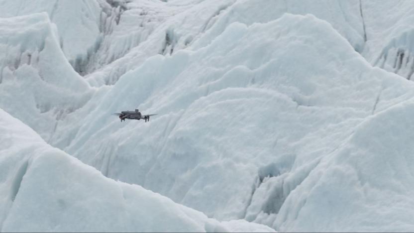
Meanwhile, the M4E mapping drone completed centimeter-level 3D modeling of the Khumbu Glacier, covering base camp, the entire Khumbu Icefall, and areas above Camp 1. Where "glacier doctors" once relied on experience and on-site markers to lay out safe routes, those ever-shifting ice crevasses now have a visual, centimeter-accurate map for the very first time.
The northern slope, without the constant flow of mountaineering logistics supplies, holds a layer of atmosphere that humans have long struggled to reach.
During the "Peak Mission" Everest scientific expedition, teams from Peking University, the Chinese Academy of Sciences, and other institutions sought answers to a question that affects all of humanity: amid global warming, can pollutants from South Asia cross the Himalayas and pour into the Tibetan Plateau? What paths do they follow? And how do glacier winds shape this entire process? To answer these questions, scientists urgently needed real, vertical distribution data of ozone and particulate matter above 8,000 meters.
Yet this was nearly an unsolvable problem: ground-based instruments can only measure a single point; satellite remote sensing lacks sufficient precision; weather balloons drift with the wind and cannot be retrieved; the downwash from rotor drones disturbs the natural wind field; exhaust from fuel-powered aircraft and helicopters contaminates samples; traditional fixed-wing planes require runways — and there is simply no runway anywhere near base camp at 5,200 meters above sea level.
This critical piece of the puzzle had long been missing.
DJI provided the solution. During a 12-day scientific expedition on the northern slope of Everest, the DJI EV50 vertical takeoff and landing (VTOL) cargo drone completed 32 takeoffs and landings, achieving a continuous climb of 3,730 meters and reaching a maximum flight altitude of 8,861 meters. It carried atmospheric data collection equipment to complete observation tasks, still retaining 30% of its battery upon return. Thanks to this drone, researchers witnessed the entire process of glacier winds from their formation to their impact for the first time — processes that once could only be inferred from models were now recorded in reality.
On the southern slope, drones pulled humans one step further away from danger; on the northern slope, they turned previously elusive atmospheric processes into measurable data. At this point, the role of drones on Mount Everest evolved from mere observers to execution tools for high-risk operations and scientific exploration.
Behind the Word "Reliable": 17 Years of Irreplicable Effort
Deploying drones to complete missions on Mount Everest is never a simple flight. It is an extreme test of comprehensive technical strength.
Low air pressure, extreme cold, strong winds, complex terrain, and ultra-high altitude simultaneously push every aspect of product performance — flight control systems, batteries, power units, communication links, and overall drone reliability — to their absolute limits.
The confidence to withstand such tests did not develop overnight.
As early as 2009, during DJI's early startup phase, founder Frank Wang, under the guidance of Professor Li Zexiang, brought a small unmanned helicopter named "Everest" equipped with the DJI XP3.1 autonomous control system to the Everest region for flight tests. That year, DJI was still a little-known brand, yet it had already chosen this harshest testing ground on Earth as its starting point.
The path that followed was paved with countless "persistent, unglamorous efforts": 18 days of aerial photography testing along the Sichuan-Tibet Highway in 2010; the Phantom 2 Vision+ flying from 4,500 meters to 5,600 meters over Mount Gongga in 2014; the Mavic 3 completing the first-ever drone aerial shot from the summit of Mount Everest at 8,848.86 meters in 2022. After 2024, the role shifted again: the FC30 cargo drone completed the world's first high-altitude transport test by a domestic civilian drone at 6,000 meters on Everest, capable of stably carrying a 15-kilogram payload at that altitude; seasonal operational deployment on the southern slope began in 2025; and in 2026, the FC100 and M4E made their joint debut.
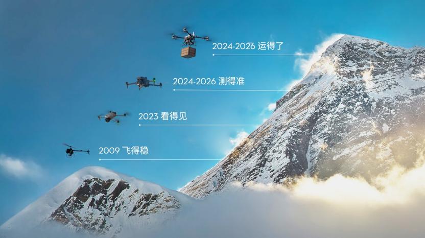
A clear evolutionary trajectory has emerged: from "can it fly?" to "can it capture footage?" then to "can it transport, can it survey, can it reliably complete missions carrying scientific instruments?" DJI's journey with Mount Everest has gone through four eras: stable flight → capturing visuals → achieving clear imaging and reliable transport → reaching higher altitudes.
The EV50 on the northern slope showcases this accumulated expertise to the fullest. Taking off from base camp at roughly 5,200 meters, it climbs all the way to 8,861 meters, where air density drops to just 39% of that at sea level, temperatures plummet to -20°C, and sudden vertical wind shear can cause a sharp drop in relative airspeed, bringing the risk of stall at any moment.
To address this extreme environment, DJI's engineering team equipped the batteries with a self-heating system to maintain consistent output in low temperatures, heated the pitot tube to prevent moist cold air from freezing and blocking the airspeed measurement channel, and programmed the flight controller to continuously monitor airspeed — if wind field changes cause airspeed to drop, it immediately adjusts thrust to pull the aircraft back to a stable state. Behind this capability, the team completed 875 test flights totaling 254 hours over a 6-month preparation period.
This is precisely DJI's core product philosophy: let machines and engineering systems handle the most complex, most dangerous parts, leaving predictable, reliable results for end users. Guides no longer need to gamble with their lives, and scientists no longer have to rely on luck. Scientific expeditions are never just promises; they are certainty forged through thousands of test flights. DJI has welded its dedication to time, patience, and obsession with pushing limits into the very DNA of its products.
From the Top of the World Back to Everyday Life
The question truly worth asking is: where will the capabilities validated on Mount Everest eventually be applied?
For DJI, Mount Everest has always served as a measuring stick, used to map the limits of products and technologies in extreme environments. The EV50 did not validate a custom-built "Everest-only drone"; instead, it validated a full set of capabilities for stable operation in complex terrain. These capabilities are ultimately meant to return to a wider range of real-world scenarios. The EV50 was originally designed to solve the far more mundane problem of 100-kilometer-class mid-range transport.
When the R&D team conducted field research in Danba County, Sichuan Province, they found that towns and villages were cut off by valleys, hillsides, and winding mountain roads. Some villages sit at a massive elevation difference from the rural roads in the valley below, making parcel delivery extremely difficult. In extreme weather, supply transport can come to a complete halt for an entire week.
Another research site was located between Ningshan County and Xi'an City in Shaanxi Province. Ningshan County has a relatively small parcel volume, so direct delivery to Xi'an is economically unfeasible. Traditional logistics routes typically require parcels to be first collected in Ankang before being transferred to Xi'an — a detour that drastically cuts into delivery speed for express items, while suitable landing spots along the route are extremely hard to find.
This clearly defined the product logic for the EV50: it must be capable of vertical takeoff and landing anywhere to break free from runway constraints, while also operating as efficiently as a fixed-wing aircraft during cruise to cover 100-kilometer-class mid-range distances. The final EV50 design adopts an 8-group vertical takeoff and landing rotor + 3-group propulsion motor configuration. The 8 vertical rotors lift the aircraft off the ground, while the 3 propulsion motors handle forward flight during cruise, with the fixed wings generating lift and the vertical rotors stopping and locking to minimize drag.
The EV50 has a maximum payload of 50 kilograms, a maximum cruise speed of 160 km/h, and a maximum effective range of 150 kilometers. Since many parcels are bulky but lightweight, the EV50 is equipped with a 270-liter cargo hold. Safety features were designed based on real operational scenarios: the aircraft can land smoothly even if some of its 8 vertical propulsion units fail, and the propulsion system is engineered to enable safe return flight even if one side's propulsion motor malfunctions.
At its core, DJI has always been answering the same set of simple, practical questions: can it carry the load? Can it fly far? Can it fly stably? Is it affordable? And can it safely complete the mission even when components fail?
In DJI's methodology, impressive technical specs are just a byproduct — real-world usability is the starting point.
The purpose of 100-kilometer-class transport drones is to complement existing logistics networks, serving regions where traditional transport is costly, high-risk, and slow. They act as "aerial capillaries" that fill last-mile gaps, allowing drones to deliver fire safety, medical, mountain rescue, and emergency communication equipment to locations that ground transport cannot reach in time. The flight control, power, mapping, transport, and scientific research capabilities proven on Mount Everest can then be brought down to lower altitudes, becoming robust, durable, affordable, and reusable tools for the general public.
In fact, this kind of protection is not something for the future — it is already happening every day. During the recent floods in Guangxi, for example, reservoirs in Yunbiao, Liulan, and other areas in Hengzhou experienced overflow and embankment breaches, leaving large swathes of villages isolated in floodwaters with no roads, no internet, and no power. Facing this disaster, DJI drones of all types rushed to the front lines: enterprise drones conducted disaster assessment and patrols, transmitting real-time footage of submerged villages, breach conditions, and trapped locations back to command centers; agricultural and transport drones were repurposed by massive numbers of drone pilots into aerial lifelines, repeatedly delivering urgently needed supplies like bottled water, instant noodles, and medicine to people trapped by floods. Over multiple isolated flood-hit villages, drones even deployed aerial ropes to hoist trapped people directly from the water and transfer them to safety. These machines, originally designed for agricultural crop spraying and mountain transport, seamlessly transformed into life-saving tools when disaster struck.
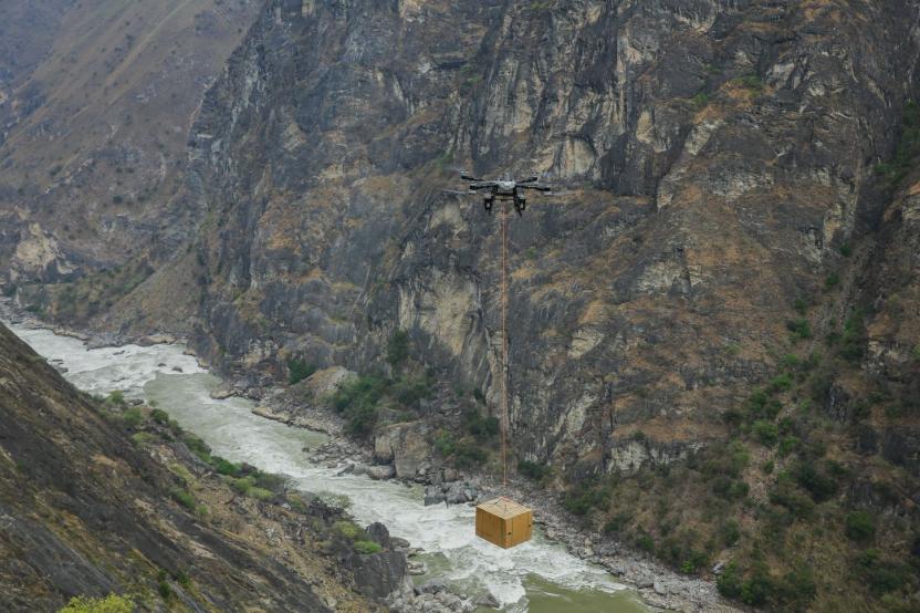
Scenarios like this are no longer rare: in more and more flood, earthquake, and wildfire emergencies, DJI drones have become one of the most common assets in emergency response systems — used for reconnaissance, public announcement broadcasting, lighting, heavy lifting, and supply delivery. They may not be the stars in the spotlight, but they have turned the promise of "protecting lives" into tangible action in every race against time.
The reliability validated on Mount Everest is continuously translating into real protection for ordinary people across mountains and plains.
This is exactly why DJI has relentlessly pushed its limits on Mount Everest for 17 consecutive years. In an era where everyone is chasing shortcuts, Mount Everest provides a testing ground that leaves no room for opportunism. It does not care about reputation or marketing gimmicks — it only rewards genuine, proven strength.
The DJI the public knows is associated with aerial photography and stunning landscapes, but the DJI on Mount Everest is dedicated to protecting lives, exploring the unknown, and solving real, pressing problems. Over 20 years, DJI has grown from mastering flight control systems to excelling in aerial photography, mapping, transport, and scientific research. The early passion of its tech enthusiasts has ultimately evolved into a warm, powerful force that protects lives and advances human understanding of the world.
Looking down from the summit of Mount Everest, what stretches out is not just vast mountain ranges — it is also farmlands, remote valley villages, island shipping routes, glacier camps, and high-altitude atmospheric layers waiting for technology to reach them.
DJI's climb has only just begun.