To "ease the pressure", Shanghai is going to dig another river.
"Shanghai's rainfall breaks a century-old record", "red rainstorm warning issued again after 13 years", "the maximum 24-hour rainfall at Xujiahui Station reaches 316 mm"...
In the past few days, affected by Typhoon Dolphin, rainfall in many areas of Shanghai has refreshed historical extremes, posing a severe test to the urban drainage system. To prevent uncontrolled water levels in inland rivers from causing larger-scale urban waterlogging, Shanghai even discharged water from Suzhou Creek to Huangpu River forcibly for the first time in history.
On August 12, at both sides of the Suzhou Creek Estuary Sluice near Waibaidu Bridge in Shanghai, the water level had dropped to a relatively safe position. Zhang Yuan (pseudonym), a duty officer, told Urban Evolution that he and his colleagues had been sticking to their posts for consecutive days, monitoring water level changes 24 hours a day and adjusting the opening and closing of the sluice in time.
Although Typhoon Dolphin has moved away, the frequent occurrence of extreme weather is still testing the response capacity of this megacity. Behind this is a historical problem that needs to be solved urgently: for more than 600 years, almost all flood water from Taihu Lake passing through Shanghai has relied on the Huangpu River, and the risk of waterlogging has always been lingering.
Not long ago, the Shanghai Water Bureau issued the "15th Five-Year Plan for Water System Governance of Shanghai", the first part of which focuses on "simultaneous management of flood and waterlogging to enhance flood control safety and resilience". Among them, the Wusong River Project (Shanghai Section) has become the top priority.
This single water conservancy project with a total investment of over 55 billion yuan and the largest scale in Shanghai's history has been under planning for decades due to its great difficulty and significance. Now, the project has entered a critical period of construction. What changes will such a large-scale investment bring to Shanghai?
01
Facing the Test
"Rainfall exceeds historical levels, and the disaster situation is beyond expectations" — local media described the extremely strong impact of Typhoon Dolphin in this way.
According to incomplete statistics, the total cumulative rainfall across Shanghai is about 500 million cubic meters. On August 9, the short-term cumulative rainfall at meteorological stations such as Xujiahui and Pudong topped the national list. The 24-hour rainfall at the national-level Xujiahui Meteorological Station reached 316.1 mm, which is the maximum value since the station had rainfall records in 1872.
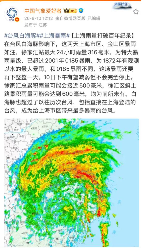
Image source: Screenshot from Weibo
Such extreme rainfall intensity has brought an unprecedented stress test to the urban flood control system.
According to Zhang Zhenyu, inspector of Shanghai Flood Control Office, Typhoon Dolphin this time caused water accumulation on hundreds of roads and underpasses in Shanghai, more than 100 communities to be flooded, over 1000 trees across the city to fall down, and more than 20,000 users to be affected by power outages.
At around 10 a.m. on August 12, the Suzhou Creek Estuary Sluice in Shanghai was slowly closed. Real-time monitoring data showed that the water levels of the inland river and the outer river on both sides of the sluice were 3.05 meters and 3.07 meters respectively, which had dropped to a relatively safe position.
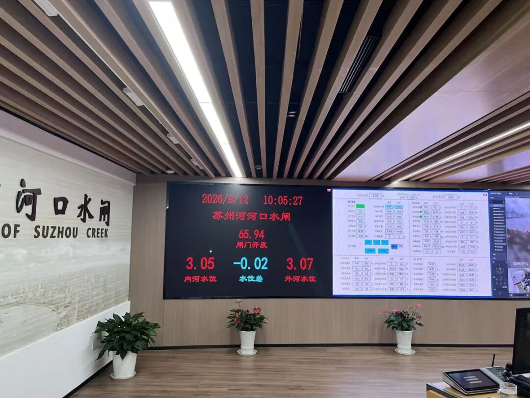
Real-time water level of Suzhou Creek Estuary Sluice Image source: photographed by Liu Songhui
The wind and rain are gradually subsiding, but they have left a more thought-provoking question for this city: the improvement of urban drainage capacity has been mentioned every year, why is the city still flooded repeatedly?
"The typhoon brought extremely high rainfall intensity, and the water level of Suzhou Creek once soared to 4.7 meters, which is a high level in history." Zhang Yuan said, although the water department had lowered the water level in advance to reserve storage capacity, the rainfall was so large that the storage capacity was still not enough to fully hold the incoming water.
Where is the problem?
According to local water department sources, after years of continuous improvement, the rainwater drainage capacity of 70% of Shanghai's central urban areas has reached the level of "once in 3 to 5 years". That is to say, when the hourly rainfall intensity reaches 51.2 mm to 58 mm, there will be no obvious water accumulation in the corresponding area. Industry insiders analyzed that this drainage standard is already at the leading level across the country.
On this basis, Shanghai is still working to raise the upper limit — on the one hand, it will popularize the drainage capacity of "once in 3 to 5 years" as soon as possible, and at the same time study the possibility of exploring higher standards in more areas. According to local plans, by 2030, the rainwater drainage capacity of about 80% of Shanghai's central urban areas will reach the level of "once in 3 to 5 years".
However, even if it reaches the level of "once in a century", it is unable to withstand the historically rare extreme heavy precipitation.
According to the analysis of relevant person in charge of Shanghai Water Bureau, while a large amount of rainwater continuously flows into Shanghai's river network, the tide levels of Huangpu River and Hangzhou Bay continue to rise, the water level of the outer river is higher than that of the inland river, the discharge of inland floodwater is restricted, and the incoming water from the upper reaches of Jiangsu and Zhejiang in the Taihu Lake Basin continues to flow in. The superposition of multiple factors leads to the high water level of the river network that does not recede.
Under pressure, on August 10 and August 11, Shanghai successively launched the emergency pump set operation of Suzhou Creek twice, to forcibly discharge the water of Suzhou Creek to Huangpu River.
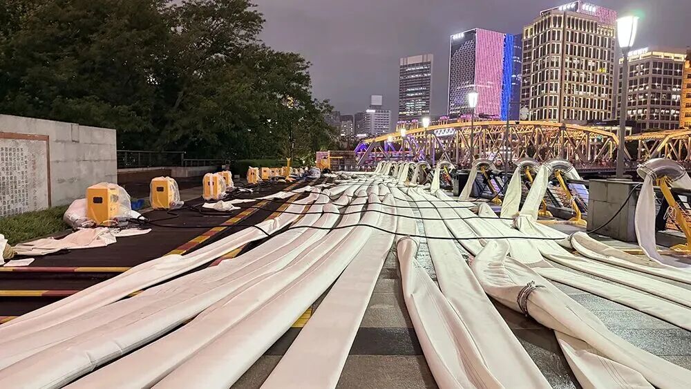
Image source: Shanghai Observer
02
Way Out
The central urban area is low-lying and lacks storage space, but the dangerous situations brought by extreme precipitation are becoming more and more frequent. Relevant studies show that Shanghai's precipitation in the past 20 years is at a peak of a century, and the annual average precipitation is increasing at a rate of 16.1 mm per year.
Shanghai, which has been troubled by water for years, is in urgent need of a new "way out".
From the perspective of geographical location, Shanghai is located in the lower reaches of the Taihu Lake Basin. Since ancient times, it has been the only way for the flood of Taihu Lake to flow eastward into the sea, and floods occurred frequently in history. Until today, 80% of the water volume in the Taihu Lake Basin will eventually flow into the main stream of Huangpu River and discharge into the Yangtze River Estuary.
Therefore, "water management" has always been an unavoidable keyword in the urban construction and development of Shanghai.
In the words of local media, although flood control facilities are upgraded every year, flood has always been the "Sword of Damocles" hanging over the head —
Some places are worrying year after year. Jiading and Baoshan are naturally low-lying, and residents are always anxious whenever flood season comes;
There are also places that can no longer afford flooding. Today, any section along the Huangpu River is a 100-billion-level industrial belt, which cannot allow the water level to exceed the warning line for a long time.
According to the paper "Spatio-temporal Distribution Law of Urban Waterlogging in Shanghai Based on Spatio-temporal Clustering", after analyzing the data related to urban waterlogging in Shanghai from 2013 to 2023, the research team of Tongji University found that from the perspective of the number of waterlogging occurrences, the total number of reported waterlogging points in Shanghai's central urban area is close to 800 times, far more than other administrative regions, among which Putuo District is significantly more than other regions; outside the city center, Pudong New Area has the largest number of waterlogging occurrences (521 times) among all administrative regions.
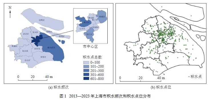
Image source: "Spatio-temporal Distribution Law of Urban Waterlogging in Shanghai Based on Spatio-temporal Clustering"
Among them, the area with the largest number of waterlogging points in the city center is exactly Putuo District, which has the longest shoreline of Suzhou Creek. According to the analysis of the paper, affected by geographical factors, the city center and the areas along the Huangpu River face greater drainage pressure.
It is urgent to "reduce the burden" on the Huangpu River. Therefore, the Wusong River Project (Shanghai Section) has been put on the agenda.
Public information shows that the Wusong River Project (Shanghai Section) is about 23 kilometers long, starting from the junction of Suzhou and Shanghai in the west, and extending eastward along the Wusong River and Yunzaobang to Chenhang near the boundary of Jiading and Baoshan Districts in Shanghai, then divided into two branches: one is to newly build Luoyun River to the north (partially using Yangjing, Puhuatang and Xiangyang River), and dredge Xinchuansha River into the Yangtze River; the other is to dredge Yunzaobang into the Huangpu River.
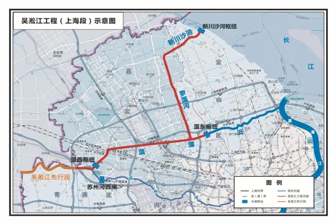
Image source: Shanghai Observer
In simple terms, it is to build a drainage "highway" for the flood of Taihu Lake directly to the Yangtze River, so as to reduce the flood control pressure of the Huangpu River and its coastal urban areas.
Lin Xianping, executive deputy secretary-general of the China Urban Expert Think Tank Committee and associate professor of Zhejiang University City College, analyzed that for Shanghai, the contradiction between short-duration heavy rainfall and the "backwater" effect of inland rivers and outer river tide levels is increasingly intensifying. The original self-flow dominated river network regulation space is continuously compressed. Relying only on the single channel of Suzhou Creek and Huangpu River to discharge flood can no longer support the flood discharge demand of the northern Jiading and Baoshan areas. This is exactly the structural short board that the Wusong River Project (Shanghai Section) must solve.
The total investment of the project exceeds 55 billion yuan, which is nearly 1.4 times the investment scale of the 20-year comprehensive environmental improvement of Suzhou Creek, making it the largest single water conservancy project in Shanghai's history, and its significance is self-evident.
03
Implementation
With such great significance, the difficulty of promotion is also extraordinary. Shanghai has been working for decades to promote the implementation of this super project.
On the one hand, as a large water conservancy project in the Taihu Lake Basin, the Wusong River Project spans Suzhou and Shanghai, and the project approval process is extremely complex; on the other hand, to squeeze out 23 kilometers of river space in Shanghai where land is extremely valuable, it involves negotiation and adjustment of farmland, communities, industrial parks, roads and other scenarios, which brings many challenges.
In recent years, the urgency of flood control and disaster reduction has become increasingly prominent, and the progress of the project has been accelerating.
According to public reports, promoting the construction of four projects including the lakeside embankment, Wusong River, the follow-up project of Taipu River and the dredging of Wangyu River was once listed as the supervision item of the Ministry of Water Resources in 2023. Relevant responsible persons of Taihu Basin Authority of Ministry of Water Resources have sent investigation teams to Jiangsu, Zhejiang, Shanghai and other places for investigation many times, to promote the project to be approved as soon as possible, speed up the construction progress, and give full play to its benefits as soon as possible.
In April 2025, all the water conservancy projects of the Wusong River Project (Shanghai Section) have been approved for construction. At present, the main structure of Xinchuansha River is basically completed, which is expected to be fully completed in 2027. The southern section of Luoyun River, the only newly excavated artificial river along the whole line, is pushing forward the preliminary work, and the project construction has entered a critical period.
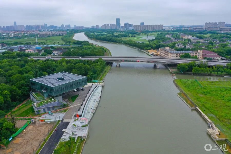
Image source: Shanghai Observer
According to the "15th Five-Year Plan for Water System Governance of Shanghai", during the "15th Five-Year Plan" period, the construction of the Xinchuansha River section, Xinchuansha River - Lianqi River section and Lianqi River - Yunzaobang section of the Wusong River Project (Shanghai Section) will be basically completed.
It is worth noting that in addition to flood discharge, local authorities have more expectations for this large-scale project. For example, it will be built as a third-class waterway that can navigate 1000-ton ships, which is expected to realize the combined transport of sea, river and inland waterway in the future, and is of great significance to promote the export of the Yangtze River Delta.
At the same time, it will also activate the whole region — benchmarking the Huangpu River and Suzhou Creek, build the Wusong River waterfront into a "world-class waterfront area", and drive the development and transformation of the surrounding areas.
Looking across the country, Shanghai is not the only place facing such urgent needs.
Li Guoying, Minister of Water Resources, previously wrote that with the intensification of the impact of global climate change, the suddenness, abnormality, extremity and unpredictability of disasters such as rainstorm, flood and drought in China have become more prominent. It is urgent to speed up the improvement of network-type water conservancy infrastructure, give full play to the advantages and network functions of the super-large-scale water network project system, enhance the capabilities of flood disaster defense, water resource overall allocation, and urban and rural water supply guarantee, and realize the unification of economic, social, ecological and safety benefits.
Among the "six networks" included in the national top-level deployment, the water network is placed in the first place, and is becoming an important battlefield for new infrastructure. According to estimates, the investment